
(Hover to zoom, OPEN or DOWNLOAD below)
Right Click Link to Save
As or Click to Open in Browser
| Hi Resolution | Med Resolution | Low Resolution |
| 48MB - 21000 x 6829 | 15MB - 10800 x 3414 | 5MB - 5184 x 1639 |
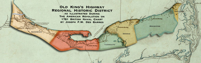
Regional Historic District 1781 |
Regional Historic District 1844 |
Des Barres | Simeon-Borden |
Walling | Bird's Eye
|
Nautical Chart CC Bay |
Capt. John Smith 1614 |
Atlantic Coast 1735 |
Barnstable 1795 |
Barnstable 1831 |
Barnstable Walling 1856 |
USCS Barnstable Harbor 1861 |
USCS Barnstable Harbor 1865
The Old King's Highway Regional Historic
District is fortunate to have access to these digitized versions of the
oldest maps of our area and are pleased to share these images with the
general public.
These maps are available for research and educational purposes only and
should not be used for commercial purposes.
They are made available through the courtesy of the Norman B. Leventhal Map
Center at the Boston Public Library, NOAA's Historical Map & Chart
Collection, The Massachusetts Archives and the generosity of other anonymous
contributor